S. Anders Brandt
Personal homepage
www.sab.geovega.se
Research
River flood modeling and visualization
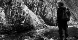
In recent years, many districts in Sweden have suffered severely from river floods. There is an increasing interest shown from physical planners, rescue organizations etc. who stress that these events must be accounted for. For example, areas for new house constructions may be located near rivers that already are a threat or that may be one in the future. New areas are also getting increasingly scarce, since all the best places to build most often already have been used.
My research focuses on the quality of elevation models and how these can be used together with hydrological models and GIS to produce inundation maps and inundation scenarios for such areas. With the research results visualized in a proper way, the affected authorities and organizations can better plan their activities.
Effects of dams and sediment flushing in reservoirs and downstream reaches
Reservoir sedimentation is a worldwide recognized problem. Without dams, the eroded soil is transported by river flows to the sea. However, when dams are built, the still water in the reservoirs allows the transported sediment to deposit. This can be a problem as the reservoir cannot function as originally thought, due to filling with sediments, but it may also lead to sediment shortage with associated probelms in the downstream reaches.
Hydraulic flushing is one method available to deal with sedimentation problems in reservoirs. During flushing, the reservoir water is released through bottom gates in the dam with the intention to erode deposited material from the reservoir bed and carrying the material to the river downstream from the dam.
My research has focused on the understanding of the active processes and resulting geomorphology, in the reservoir and the downstream reaches, during both "normal" conditions and the special ones that prevail during flushing.
See publications on effects of dams and sediment flushing in reservoirs and downstream reaches.
For years I have tried to incorporate multicriteria decision analyses (MCDA) into the geographical information systems (GIS) courses I teach and several of my students have written theses on various topics involving spatial MCDA. Right now I am also involved in some research in collaboration with others on this topic.
See publications on spatial multicriteria decision analysis.
-
Home
-
Publications
-
Teaching
-
Shooting
-
Lattjolajbanlådan
